
 Raul Delapena Setiawan
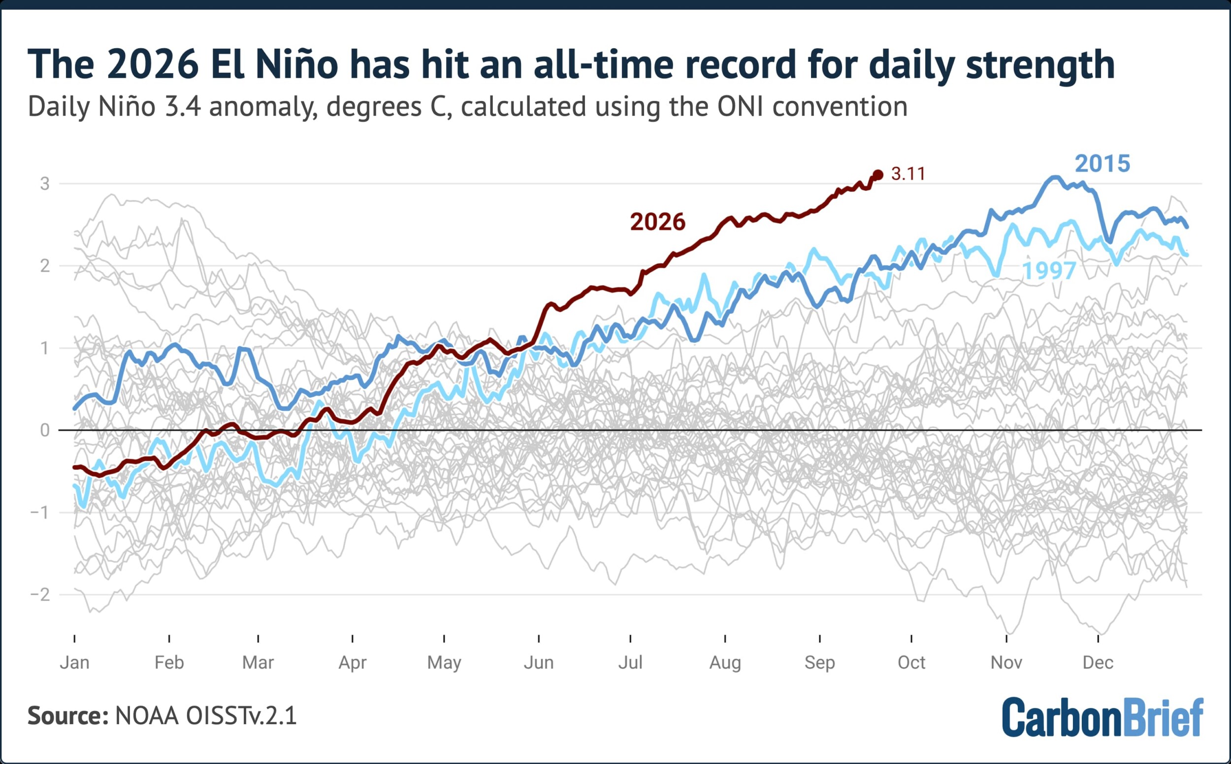
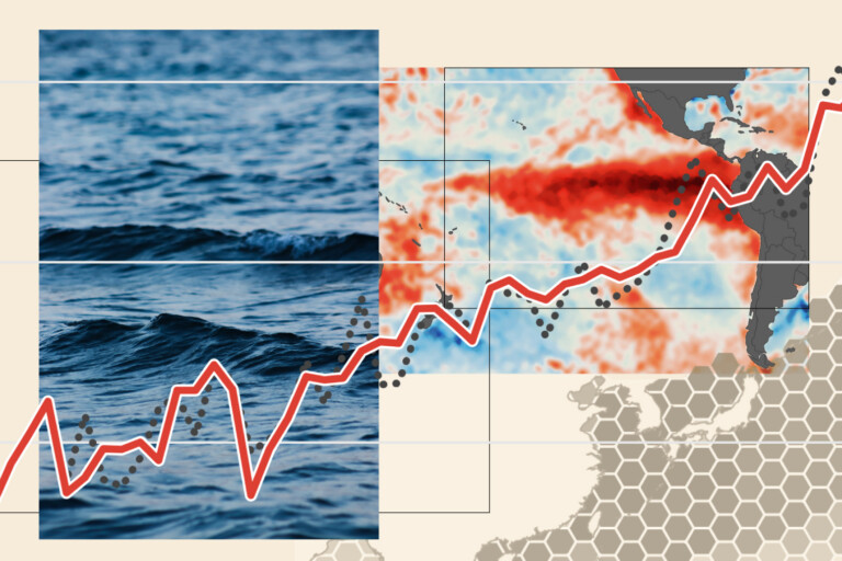
The global climate system is currently navigating an unprecedented stress test. The 2026 "super El Niño"—a naturally occurring climate phenomenon characterized by a profound warming of the tropical Pacific Ocean—has officially entered uncharted territory. As of September 21, 2026, daily sea surface temperature anomalies in the critical Niño 3.4 region have surged to 3.11°C, eclipsing the previous daily record of 3.08°C set in November 2015.
This development is not merely a statistical anomaly; it represents a significant departure from historical climate norms. While El Niño events are cyclical and known to temporarily elevate global average temperatures, the velocity and intensity of the current event have caught the international scientific community by surprise. With the event expected to persist well into next year, the world is preparing for a period of extreme meteorological disruption.

The Anatomy of an Unprecedented Event
El Niño operates by reshaping global weather patterns, often bringing drought to regions like Indonesia and Australia, while triggering heavy rainfall and flooding in parts of the Americas. Its intensity is traditionally measured via the Niño 3.4 anomaly, which calculates the deviation of sea surface temperatures in the central Pacific from a 30-year average.
What distinguishes the 2026 event is its precocity. Typically, El Niño events gain momentum throughout the autumn, peaking in late November or December. The fact that this event has shattered records before the autumn equinox suggests that we are witnessing an accelerated intensification process. Every major "strong" El Niño recorded since 1982 has continued to strengthen after mid-September; if this historical pattern holds, the 2026 event is poised to reach magnitudes that existing climate models struggle to fully project.
Technical Metrics: ONI vs. RONI
To monitor this phenomenon, researchers rely on two primary indices:
- Oceanic Niño Index (ONI): This remains the industry standard. By subtracting the most recent 30-year average from current temperatures, scientists isolate the El Niño signal from long-term, human-driven background warming. Under this metric, the 2026 event has already set an all-time record.
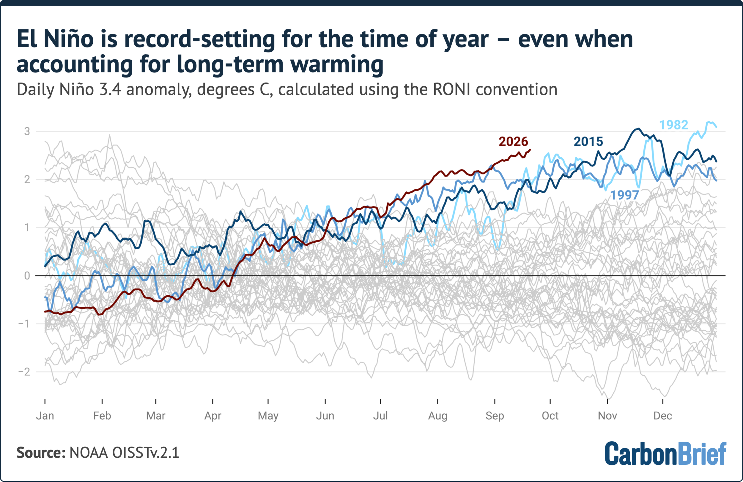
- Relative Oceanic Niño Index (RONI): Introduced by NOAA in 2024, the RONI attempts to filter out the broader warming of the tropical oceans attributed to climate change. While this provides a more localized view of the El Niño signal, it often underestimates the total heat content of the current event, which transcends the narrow Niño 3.4 geographic boundary.
Even under the more conservative RONI metrics, the 2026 event is tracking toward the upper echelon of historical intensity, sitting significantly higher than the typical threshold for "very strong" events (defined as anomalies above 2.0°C).
A Chronology of Intensification
The current event has been in motion since June 2026, and its trajectory has been remarkably aggressive.
- June – August 2026: The onset phase showed early signs of extreme heating. By August, monthly anomalies reached 2.45°C, a level only surpassed in recorded history by the 2015-16 event and the historical reconstruction of the 1877-78 event.
- Early September 2026: Scientific discourse shifted from observing a "strong" event to acknowledging a "record-breaking" one. Researchers noted that anomalies were trending over 1°C higher than comparable points in the 1997 and 2015 cycles.
- September 21, 2026: The official crossover occurred. Daily Niño 3.4 anomalies hit 3.11°C, officially passing the peak record set during the 2015 "very strong" El Niño.
- The Forecast (Late 2026): Seasonal forecast models—incorporating data from 14 international climate centers—are in near-unanimous agreement that the event will peak between November and January.
Supporting Data: The Model Consensus
The predictive capacity of modern climate science is being tested by the current event. Current seasonal models suggest a peak monthly anomaly of approximately 4.1°C, with a range of probability spanning from 3.4°C to 4.6°C.
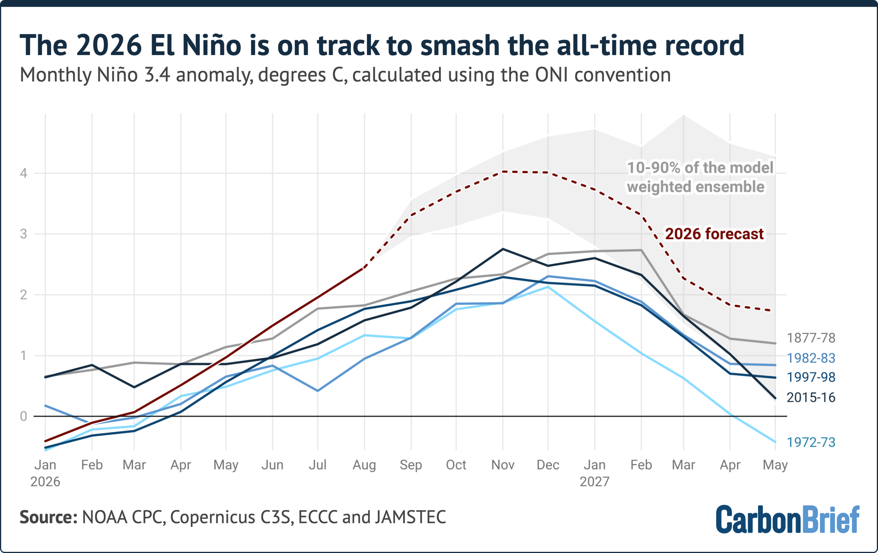
It is important to emphasize that no current seasonal forecast system has been validated against a 4°C+ anomaly, as such a value has never been documented in the instrumental era. There is a inherent "noise" in daily El Niño fluctuations, and climate scientists advise caution when interpreting these models. However, the uniformity of the forecasts across global institutions—including Copernicus, NOAA, and ECCC—provides a sobering outlook. The projected margin by which this event will exceed the 2015-16 record is, in itself, larger than the historical gap between the strongest and fifth-strongest events of the last 150 years.
Implications for the Global Climate
The primary concern among climatologists is the "lag effect." El Niño impacts on global temperatures do not happen in real-time; there is a delay of several months as the heat energy from the Pacific redistributes through the atmosphere. Consequently, while 2026 is already on track to be the warmest or second-warmest year in recorded history, the most acute impacts of this super El Niño are expected to materialize in 2027.

Regional and Environmental Cascades
The consequences of such a high-magnitude event extend far beyond surface temperature charts:
- Wildfire Risk: Research indicates that 2026 fire emissions in Indonesia are currently on track to match the highest levels seen this century. The drying of peatlands and tropical forests creates a feedback loop that releases massive amounts of carbon, further complicating global mitigation efforts.
- Agricultural Disruption: Shifting precipitation patterns threaten food security in major grain-producing regions. Historically, strong El Niño years are correlated with significant crop yield reductions in South and Southeast Asia.
- Marine Ecosystems: The sustained, extreme warmth in the tropical Pacific is placing severe stress on coral reef systems and migratory fish populations, potentially devastating local economies dependent on maritime resources.
Scientific and Policy Responses
The scientific community is currently engaged in a massive data-gathering effort to understand if the 2026 event is a "new normal" influenced by the compounding effects of anthropogenic global warming, or a "black swan" event exacerbated by specific atmospheric conditions.
"We are essentially flying without a map," noted one climate researcher following the release of the latest NOAA data. The reliance on 30-year baselines is becoming increasingly problematic in a world where the baseline itself is shifting upward due to climate change. Policymakers are being urged to integrate these new, high-intensity projections into disaster preparedness and long-term infrastructure planning.
The World Meteorological Organization (WMO) and national agencies are advising that the next six months will be critical. Governments in high-risk zones are being prompted to implement early-warning systems for heatwaves, floods, and food insecurity, recognizing that the "super" nature of this El Niño increases the probability of extreme weather events occurring simultaneously across different continents.

Conclusion: A New Frontier
As we move into the final quarter of 2026, the global focus remains fixed on the Pacific. The breaking of the 3.11°C threshold is more than a record; it is a signal that the climate system is capable of shifts that exceed our historical experience.
Whether the 2026-27 event peaks at the forecasted 4°C or modulates slightly, the era of "super El Niños" has arrived with a force that demands a re-evaluation of global climate risk. The coming months will be a defining period for climate science, serving as a real-world crucible that will determine the accuracy of our most sophisticated models and the resilience of our global society. As the world waits to see how the atmosphere responds to this record-breaking heat, one thing is certain: the environmental impact of 2026 will resonate well into the future, shaping the climate policy and ecological reality of the coming decade.


 Laily UPN
 Dwi Wanna
 Basiran
 Neng Nana
 Iffa Jayyana

 Rifan Muazin
 Asro
Asro