
 Siti Muinah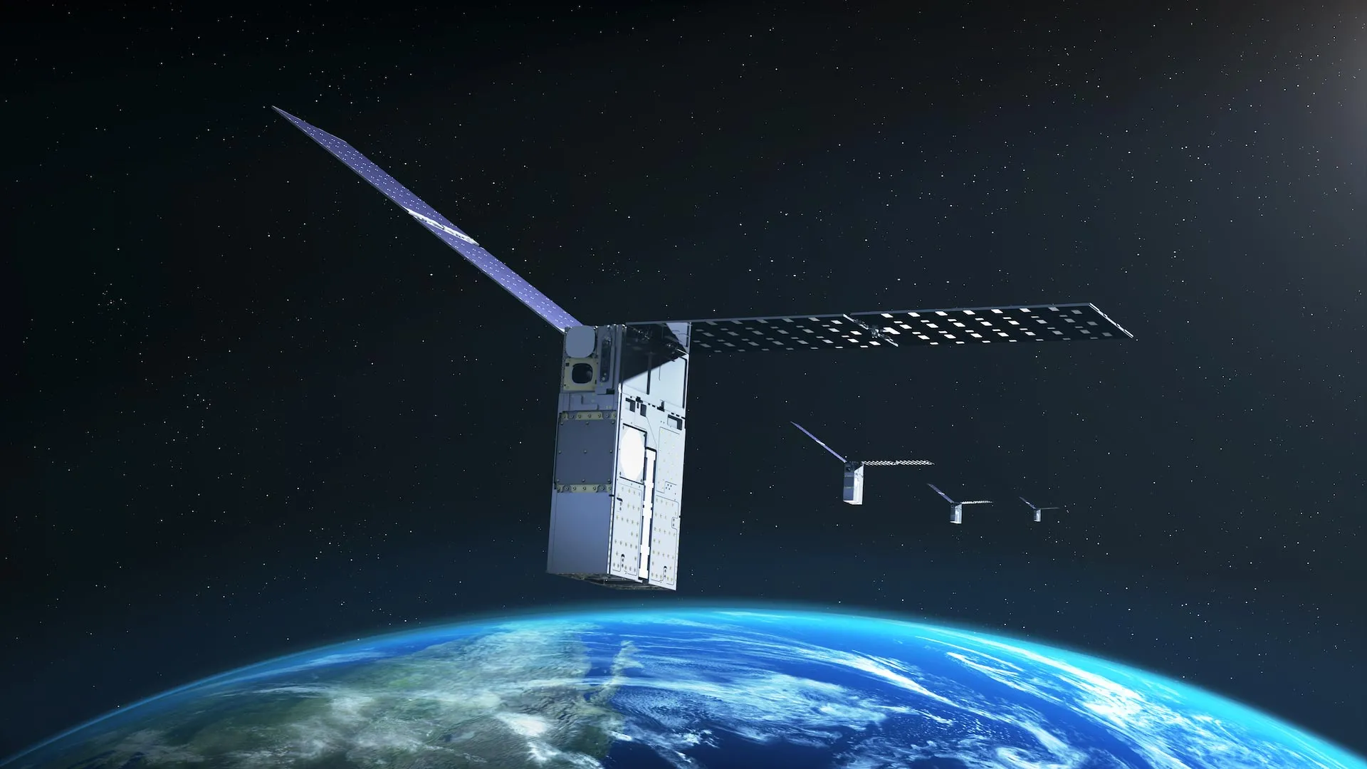
In a landmark achievement for the future of space exploration, NASA’s Starling mission has successfully demonstrated a revolutionary navigation system that allows satellites to determine their orbital position without relying on Earth-based networks. By utilizing objects already present in space—such as other satellites and orbital debris—as celestial reference points, the mission has effectively bypassed the need for traditional Global Positioning System (GPS) signals. This capability, powered by the Fast Autonomous Lost-in-space Catalog-based Optical Navigation (FALCON) system, marks a pivotal shift toward true autonomy for spacecraft operating in the deep reaches of the solar system.
The FALCON Breakthrough: Redefining Orbital Positioning
For decades, the standard for orbital navigation has been tethered to GPS, a robust network that works seamlessly in low-Earth orbit. However, as humanity sets its sights on the lunar surface, Mars, and beyond, the reliability of terrestrial navigation signals diminishes. In deep space, the reliance on ground-based tracking stations creates latency issues and vulnerability to communication blackouts.
FALCON, a joint flight experiment developed by NASA in collaboration with the Stanford University-affiliated startup EraDrive, solves this by turning a spacecraft’s "eyes" toward the immediate environment. Using Starling’s onboard star tracker cameras—instruments traditionally used for orientation—FALCON identifies surrounding objects and cross-references them with a pre-loaded catalog of known space entities. By triangulating its position against these objects, the satellite can calculate its exact orbit in real-time, completely independent of Earth.
"FALCON is yet another success for the Starling demonstration mission," said Roger Hunter, program manager for NASA’s Small Spacecraft and Distributed Systems program at Ames Research Center. "The results from FALCON can have far-reaching implications for on-orbit space-traffic monitoring, collision avoidance, and alternative navigation. The number of ‘firsts’ from Starling just keeps growing."
Chronology: From Academic Concept to Orbital Reality
The journey of FALCON represents a textbook example of NASA’s ability to incubate high-risk, high-reward research into mature commercial technology.
- The Inception Phase: The technology began as part of the University SmallSat Technology Partnerships, a NASA initiative designed to foster innovation within academic institutions. Researchers at Stanford University developed the underlying algorithms and software architecture, eventually spinning off into the company EraDrive.
- The Integration Phase: EraDrive’s "Era-Core" flight software was integrated with the Starling spacecraft’s existing optical hardware. This synergy allowed the spacecraft to process complex visual data in real-time without overwhelming the satellite’s onboard computer.
- The Launch: The Starling mission was launched in 2023, serving as the primary testbed for the new software.
- The Verification Phase (Recent): Over a critical three-day window, the FALCON system was activated. It scanned the surrounding environment, identified over 200 space objects, and successfully updated their orbital parameters while simultaneously refining its own location.
- The Future Roadmap: Later this year, the mission is scheduled to advance to the next phase, where the four individual spacecraft in the Starling swarm will begin sharing tracking data with one another to create a collective, highly accurate positioning network.
Supporting Data: Precision and Autonomy in Action
The effectiveness of FALCON was demonstrated through rigorous testing against a catalog of approximately 20,000 known space objects. During the mission, the Starling spacecraft did not merely observe these objects; it actively processed their telemetry and compared it against predicted data provided by ground stations.
The results were statistically significant. By correlating its camera observations with the onboard catalog, the FALCON software was able to:
- Improve Orbital Estimates: The system successfully refined the predicted orbits of over 200 debris objects and satellites.
- Surpass Ground Accuracy: In several instances, the onboard, autonomous calculations provided by FALCON were more precise than the data supplied by terrestrial ground stations.
- Autonomous Correction: The entire process was conducted without a single command from human operators on the ground, proving that modern flight software can handle complex navigation tasks under extreme conditions.
These metrics provide a compelling argument for the future of "distributed science," where multiple satellites must maintain a precise formation to collect data. Without the need for constant ground-based recalibration, these swarms can maintain their configuration for longer periods, even when they are on the far side of the Moon or in transit to Mars.
Official Responses and Strategic Implications
The implications for the aerospace industry are substantial. As the density of orbital traffic increases, the risk of collisions becomes a primary concern for space agencies and commercial satellite operators alike.
"The ability to update catalogs onboard is a game-changer for space traffic management," says an industry analyst. "Currently, if a satellite detects a potential collision, it must wait for ground-based verification, which takes time. With FALCON, the satellite can verify the threat itself and maneuver autonomously."
NASA’s support of this technology aligns with the Artemis program’s goals. As we establish a permanent human presence on the Moon, the requirement for a local navigation network—a "Lunar GPS"—will become paramount. FALCON provides the blueprint for how a network of small satellites can create an autonomous "mesh" of navigation, ensuring that astronauts and robotic explorers can always determine their location, regardless of their proximity to Earth.
Furthermore, the collaboration between NASA Ames and EraDrive demonstrates a successful model for public-private partnerships. By providing a platform for testing in the harsh environment of space, NASA has helped validate a commercial product that will likely become a standard component in future satellite buses.
Challenges and Future Frontiers
Despite the success of the mission, the road to total autonomy remains paved with challenges. The current version of FALCON relies on a pre-loaded catalog of space objects. As missions venture deeper into the solar system, where the density of known, cataloged objects is lower, the system will need to adapt. Researchers are already looking into ways to incorporate celestial navigation (using stars and planets) alongside object-based tracking to ensure redundancy.
The next stage of the Starling mission is highly anticipated. By moving from a single-spacecraft test to a multi-spacecraft swarm interaction, NASA intends to demonstrate that collective intelligence can outperform the individual. If four satellites can share observations and refine their combined position, it would pave the way for "sensor webs"—vast networks of small satellites that function as a single, massive, intelligent observatory.
Conclusion: A New Era of Space Exploration
The Starling mission has proven that the future of space navigation is not tethered to Earth. By successfully transitioning from a university research project to a robust, flight-proven technology, FALCON has demonstrated that autonomous, optical navigation is no longer a science-fiction trope, but a viable, scalable, and essential tool for the next century of space flight.
As the Starling satellites continue their dance in orbit, they are not just performing a demonstration; they are mapping the future. Whether it is preventing collisions in crowded low-Earth orbits or guiding human settlers across the lunar surface, the ability for a machine to look at its surroundings and say, "I know where I am," is perhaps the most significant step we have taken toward becoming a truly space-faring civilization. Through the lens of FALCON, the stars are no longer just points of light—they are the landmarks of a new frontier.

 Ali Ikhwan

 Lina Irawan
 Muslim