
 Muslim
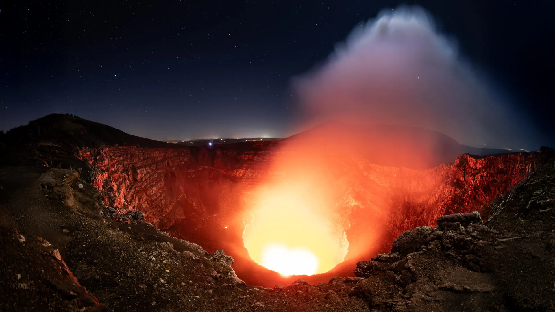
Nicaragua’s Masaya volcano, renowned globally for its mesmerizing, persistent lava lake, has long been a subject of geological fascination. However, recent research conducted by scientists at Penn State suggests that beneath the iconic crater lies a far more intricate and dynamic plumbing system than previously imagined. By peeling back the layers of the earth through advanced satellite technology, researchers have uncovered evidence of two distinct, independently behaving magma reservoirs. This discovery not only reshapes our understanding of Masaya’s subterranean architecture but also provides a vital framework for monitoring a volcano that sits in the shadow of 2 million residents.
The Dual-Reservoir Discovery: A New Paradigm
For years, volcanologists treated Masaya as a singular, albeit volatile, system. The new study, published in the journal Geophysical Research Letters, challenges this simplification. Researchers identified that the volcano’s ground deformation patterns are not uniform, suggesting that at least two separate magma sources are operating simultaneously—and often in opposition to one another.
The study, led by recent Penn State geosciences graduate Lizzie Johnson, utilized six years of high-resolution satellite data to track subtle movements on the volcano’s surface. The data revealed a striking dichotomy: while the broader caldera region underwent a cycle of subsidence (sinking) followed by uplift (rising), the area immediately surrounding the active Santiago crater exhibited a persistent, independent downward trend. This misalignment of movement is a smoking gun for researchers, pointing to the existence of a deep, primary reservoir being recharged by fresh magma, and a shallower, secondary reservoir near the crater that is losing volume.
Chronology of a Volcanic Investigation
The investigation spanned from 2018 to 2024, a period that allowed researchers to move beyond snapshot observations and analyze long-term, cyclical behaviors.
- 2018–2021 (The Subsidence Phase): During the initial years of the study, satellite observations recorded a gradual sinking across the Masaya caldera. This suggested that magma was being withdrawn or cooling within the subterranean chambers, leading to a loss of internal pressure.
- 2021–2024 (The Inflation Phase): As the study progressed into its latter half, the ground within the caldera began to rise. This "inflation" is a classic hallmark of volcanic activity, indicating that new, molten material was likely migrating into the deep reservoir, forcing the surface upward.
- The Anomaly (2018–2024): Throughout the entire six-year window, the area directly adjacent to the Santiago crater continued to subside. This independent behavior served as the critical evidence that the shallow plumbing system was detached from the deeper, larger reservoir, suggesting that the lava lake was being fed by a separate, perhaps depleting, source.
The Technological Edge: InSAR and Satellite Precision
The success of this research relied heavily on the Sentinel-1 satellite constellation and a technique known as Interferometric Synthetic Aperture Radar (InSAR). In the context of tropical volcanology, where thick cloud cover often renders optical satellite imagery useless, InSAR acts as an "all-seeing" eye.
InSAR works by emitting microwave signals that penetrate clouds and vegetation, bouncing off the Earth’s surface and returning to the satellite. By comparing the phase of these returning signals over time, researchers can measure surface displacement with millimeter-level precision. This allowed the Penn State team to map the "breathing" of the volcano—the subtle rising and falling of the ground that acts as a heartbeat for the magma reservoirs hidden miles below.
"Cloud penetration is essential for volcanoes like Masaya," explained Dr. Young Cheol Kim, who contributed to the study during his doctoral research. "Because we are operating in a tropical environment, conventional sensors would be blind for much of the year. InSAR allows us to maintain a continuous, decade-long record of these movements, which is the only way to distinguish between normal volcanic ‘noise’ and a precursor to a dangerous eruption."
Implications for Public Safety and Hazard Mitigation
The stakes for this research are exceptionally high. Masaya is not a remote peak; it is a centerpiece of a national park, a magnet for international tourism, and a looming geological presence near Managua, the capital city of Nicaragua. Approximately 2 million people live within a 13-mile radius of the volcano.
While the current research does not suggest an immediate threat of a major eruption, the implications for long-term hazard mitigation are profound. By establishing a "baseline" of normal behavior—identifying how the volcano naturally inflates and deflates—scientists can now more easily spot anomalies. A deviation from these established patterns could serve as an early warning signal, allowing authorities to evacuate or prepare communities well in advance of a potential crisis.
Furthermore, Masaya presents a persistent hazard that does not require an eruption to manifest: gas emissions. The volcano is a constant source of sulfur dioxide. Understanding the magma supply system helps experts predict when these emissions might intensify. As Lizzie Johnson noted, "Having a thorough understanding of Masaya’s volcanic activity and its related hazards is critical. Even without a major eruption, the volcano’s persistent degassing produces dangerous concentrations of gas that impact the air quality for millions."
Official Perspectives: The Scientific Process
The study represents a milestone in academic collaboration, blending high-level computational modeling with field-based geophysics. For the researchers, the project was also a masterclass in the scientific process.
Lizzie Johnson, who has since transitioned to a doctoral program at the University of Hawaii at Manoa, emphasized that the project provided more than just data; it provided a methodology for future disaster preparedness. "I learned how a research group functions, how to manage large datasets, and how to translate complex geodetic signals into real-world insights," she said.
The research was supported by the U.S. National Science Foundation, underscoring the importance of international cooperation in monitoring global volcanic risks. The findings are expected to serve as a blueprint for studying other basaltic, lava-lake-hosting volcanoes around the world. These types of volcanoes, characterized by their "open" vent systems, often behave in unpredictable ways; by applying the Masaya model, researchers hope to demystify the underground plumbing of similarly active peaks in Hawaii, Iceland, and beyond.
Future Directions: From Modeling to Monitoring
As the scientific community looks to the future, the integration of InSAR data with seismic wave imaging—a technique Johnson is now pursuing in her doctoral work—promises to provide a 3D "CAT scan" of volcanic interiors. By combining surface movement data with internal seismic signatures, scientists hope to eventually move from reactive monitoring to proactive forecasting.
The Masaya study concludes that the complexity of volcanic systems is often underestimated. What looks like a single, glowing lake on the surface is merely the tip of a vast, multi-chambered system. For the residents of Nicaragua, this scientific vigilance is the best defense against the unpredictable nature of the earth beneath their feet. As researchers continue to refine their computer models and satellite tracking, the goal remains clear: to ensure that the "glowing lake" of Masaya remains a destination for wonder, rather than a catalyst for catastrophe.

 Basiran


 Evan Lee Salim

 Reynand Wu

 Layla Zulfa

 Nana
