
 Lina Irawan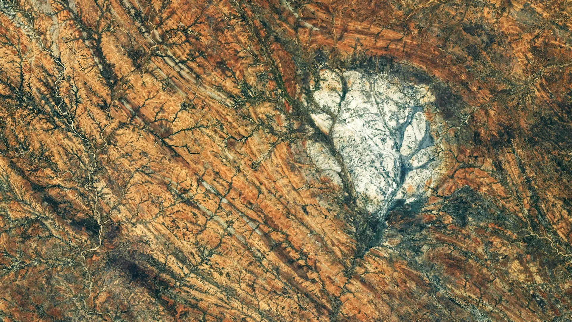
In the vast, arid expanse of southern Madagascar, an unusual, brilliant patch of rock catches the eye of anyone looking down from the heavens. Seen from the vantage point of the International Space Station (ISS), this formation stands in stark, reflective contrast to the rugged, deformed terrain that characterizes the region. Known to geologists as the Saririaky anorthosite massif, this sprawling 100-square-kilometer body of rock is more than just a terrestrial curiosity; it is a direct geological mirror to the lunar highlands that glow in our night sky.
On August 28, 2026, a member of the Expedition 75 crew aboard the ISS captured a high-resolution image of this massif, highlighting its distinct, roughly circular signature. While the rock—anorthosite—is rare in its purity, it is a primary constituent of the Moon’s crust. By studying these terrestrial "Moon rocks," scientists are gaining unprecedented insights into the violent history of Earth’s crustal assembly and the primordial cooling of our satellite.
The Geological Anatomy of Anorthosite
Anorthosite is an intrusive igneous rock composed primarily of plagioclase feldspar. Its formation is a testament to the slow, deliberate pace of deep-crustal cooling. Unlike volcanic rocks that erupt and solidify rapidly upon reaching the surface, anorthosite forms beneath the crust, allowing minerals to grow into large, reflective crystals.
On the Moon, these rocks are the building blocks of the bright, pale lunar highlands. These regions represent the earliest crustal material of the Moon, formed over 4 billion years ago when the lunar surface was little more than a roiling global ocean of molten magma. As this "magma ocean" cooled, lighter minerals crystallized and floated to the surface, creating the white, reflective crust we see today.
While Madagascar’s Saririaky massif is a terrestrial analog, its presence here is the result of vastly different tectonic processes. It is a portal into the Precambrian eon, representing a time at least 600 million years ago when the geological architecture of our planet was being forged in the crucible of continental collisions.
A Chronology of Collision: The Assembly of Gondwana
To understand why a piece of "lunar-like" rock is embedded in the heart of Madagascar, one must look back hundreds of millions of years. The Saririaky formation is not an isolated geological event; it is a prisoner of a massive "ductile shear zone."
The Precambrian Forge
During the late Precambrian, Earth’s landmasses were engaged in a slow-motion dance that would eventually culminate in the formation of Gondwana, the massive supercontinent that encompassed modern-day Africa, India, Madagascar, Australia, and Antarctica. As these massive continental fragments drifted toward one another, the tectonic pressures were incomprehensible.
The Deformation of the Crust
Within the ductile shear zones surrounding Saririaky, the rocks did not merely shatter; they flowed. Under the intense temperatures and pressures of the deep crust, solid rock became plastic. It was stretched, folded, and bent over millions of years. Geological surveys of the region have identified long, north-to-south trending features—foliation patterns—that record the direction and magnitude of the forces that squeezed the region.
The Boudinage Effect
One of the most compelling theories regarding the Saririaky massif involves a process called boudinage. Approximately 60 kilometers north of the main Saririaky body lies another anorthosite massif. Many researchers hypothesize that these two formations were once a single, continuous body of rock. As the tectonic plates shifted and the crust was subjected to extreme lateral tension, the original mass was pulled apart like taffy, with the tougher, more brittle anorthosite breaking into the distinct "boudins" (or segments) we see today. This theory provides a structural map of the forces that helped stitch together the supercontinent of Gondwana.
Supporting Data: Comparative Planetology
The scientific value of studying terrestrial anorthosite cannot be overstated. With lunar samples in limited supply—most of which were collected during the Apollo missions of the late 1960s and early 1970s—Earth-based formations serve as vital laboratories.
The Montana Connection
While Madagascar provides a spectacular look at the metamorphic history of anorthosite, it is not the only site of interest. The Beartooth Mountains in Montana, USA, contain anorthosite deposits that possess a mineralogical composition nearly identical to specific samples retrieved from the Moon. By analyzing how these rocks respond to Earth’s unique weathering and tectonic environment, geologists can calibrate their models to better interpret the lunar samples currently housed in NASA’s curation facilities.
Remote Sensing and Orbital Analysis
The use of the Nikon Z9 digital camera by ISS astronauts to document such sites has revolutionized geological mapping. The high-resolution imagery allows scientists to identify large-scale structural patterns—such as the circular outline of the Saririaky massif—that are often obscured at ground level. These orbital views allow for a "big picture" synthesis, linking small-scale mineral samples to the massive tectonic events that shape entire continents.
Official Perspectives and Academic Context
The geological community views the Saririaky massif as a "smoking gun" for the tectonic history of the African-Madagascan shield. Research published in peer-reviewed journals, such as the Contributions to Mineralogy and Petrology, emphasizes that the massif is a primary record of the thermal evolution of the lower crust.
NASA’s Earth Science and Remote Sensing Unit at the Johnson Space Center maintains that the documentation of such features is a priority for the ISS mission. "These photographs are not merely for public outreach," stated a NASA spokesperson. "They provide essential data points for geologists who study the Earth as a system. When we can correlate the structural deformation in Madagascar with the mineralogical makeup of the lunar highlands, we are essentially building a bridge between two worlds."
The imagery obtained on August 28, 2026, has been integrated into the database of the ISS Crew Earth Observations Facility, where it is available for comparative studies alongside Landsat satellite imagery. These data sets confirm that the Ampanihy ductile shear zone, which hosts the massif, is one of the most significant records of Precambrian crustal shortening in the Southern Hemisphere.
Implications: Understanding Our Origins
The study of the Saririaky massif is a study of two types of origins: the origin of the Moon and the origin of our home continent.
Lessons from the Moon
By comparing the Saririaky formation with lunar anorthosite, scientists are refining their understanding of the "Magma Ocean" hypothesis. If the cooling rates and crystallization sequences observed in Madagascar match the lunar signatures, it provides stronger evidence for the prevailing theories of how the Moon’s crust was solidified. It validates the timeline of lunar development, helping scientists pinpoint when the Moon shifted from a molten sphere to a stable, rocky satellite.
Lessons from Earth
On Earth, the massif serves as a permanent record of the "Gondwana assembly." It proves that the same forces that shaped our present-day continents are capable of taking massive, deep-crustal rocks and moving them across thousands of kilometers of space and time. The "stretching" of the Saririaky massif serves as a reminder of the raw power of plate tectonics.
The Future of Geological Research
As we look toward future lunar exploration, specifically the Artemis missions, the demand for terrestrial analogs will only grow. Astronauts training for lunar surface operations often study sites like Madagascar and the Beartooth Mountains to learn how to identify, categorize, and sample anorthosite in the field. The Saririaky formation is, in effect, a training ground for the next generation of lunar geologists.
Conclusion
The Saririaky anorthosite massif is more than just a bright spot on a map. It is a geological bridge between the Earth and the Moon, and a historical archive of the supercontinent era. As the ISS continues to orbit our planet, each photograph of such regions adds another piece to the puzzle of how our world—and our neighbor—came to be. Through the lens of an astronaut’s camera, we are reminded that whether we look at the white, scarred face of the Moon or the dusty, ancient plains of Madagascar, we are looking at the same fundamental story of heat, pressure, and time.
Technical Data of the Observation:
- Mission: Expedition 75
- Date of Acquisition: August 28, 2026
- Image ID: ISS075-E-85249
- Equipment: Nikon Z9, 400mm lens
- Location: Southern Madagascar, Saririaky Massif
- Primary Feature: Anorthosite intrusive igneous rock, Precambrian era


 Rifan Muazin

 Nana
Nana
 Ali Ikhwan
 Evan Lee Salim