
 Neng Nana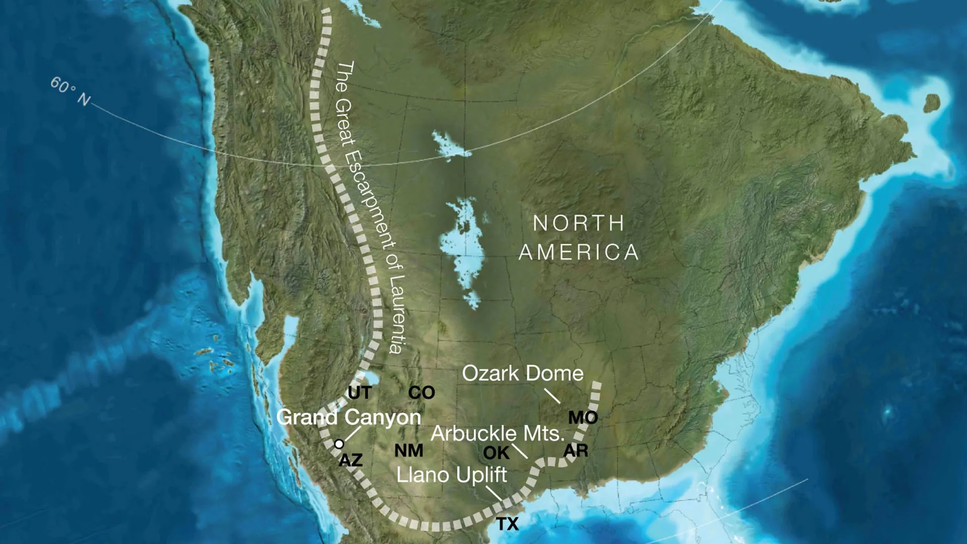
For generations, the Grand Canyon has been viewed through the singular lens of the Colorado River—a majestic, winding sculptor that spent the last six million years carving through layers of time. However, a groundbreaking study published in the journal Geology has fundamentally shifted this narrative. An international team of scientists has uncovered evidence that the Canyon’s most dramatic features—and its most enduring mysteries—were set in motion nearly a billion years before the river even existed.
The research, led by the University of Southampton, proposes that the Grand Canyon’s deepest, most ancient rocks were exposed not by a river, but by a colossal, long-vanished cliff system born from the tectonic breakup of the supercontinent Rodinia. This discovery offers a radical new explanation for the "Great Unconformity," a notorious billion-year gap in the geological record that has perplexed scientists for over a century.
A Chronology of Continental Transformation
To understand the scale of this discovery, one must look back to the Neoproterozoic era, approximately 800 million years ago. At this time, the Earth looked nothing like the modern map. The supercontinent Rodinia was beginning to fracture, a process that triggered massive tectonic shifts along what would eventually become the western edge of North America.
The Rise of the Great Escarpment
As Rodinia pulled apart, the crustal thinning and thermal activity created a "Great Escarpment." These were not mere hills, but towering, vertical cliffs reaching heights of up to one kilometer, stretching for thousands of kilometers along the continental margin.
Over tens of millions of years, this massive topographical feature acted as a tectonic conveyor belt. As the continent drifted and shifted, the escarpment migrated inland, relentlessly eroded by the elements. This slow, grinding process stripped away as much as eight kilometers of rock from the surface, effectively "exposing" the ancient crystalline basement rocks that now form the foundational architecture of the Grand Canyon in southern Arizona.
The Long Erosion
The study suggests that the modern landscape of the American Southwest is merely the final, downstream consequence of this prehistoric phenomenon. By comparing the ancient North American landscape to modern analogues—such as the Great Escarpment of South Africa or the coastal cliffs of Brazil—researchers have been able to reconstruct a "lost" topography. This mountainous rim likely governed the paths of ancient river systems and the movement of sediments across the continent long before complex life flourished during the Cambrian explosion.
Supporting Data and Geological Modeling
The investigation, a collaborative effort involving the University of Southampton, the GFZ Helmholtz Centre for Geosciences, the University of Potsdam, and the University of Illinois Urbana-Champaign, relied on an innovative synthesis of plate tectonic reconstruction and landscape evolution modeling.
Decoding the Great Unconformity
One of the central challenges in geology has been the "Great Unconformity"—a mysterious absence of rock layers that occurs across the globe, representing a period where billions of years of geological history seem to have vanished.
"Our paper suggests the Canyon’s basement rocks were progressively brought to the surface as part of an immense escarpment that developed during the breakup of an ancient supercontinent," explains Thomas Gernon, Professor of Earth Science at the University of Southampton and lead author of the study.
The data confirms that the erosion associated with this ancient escarpment was not uniform. By modeling the tectonic uplift related to continental rifting, the team demonstrated that the escarpment created high-altitude, steep terrain. This provided the necessary "headroom" for ancient rivers and glaciers to systematically strip away overlying strata, creating the dramatic geological "missing link" we observe today.
Mapping the Lost Rim
The study identifies that this ancient escarpment was not limited to the modern-day borders of Arizona. Instead, the research team suggests it crossed a vast swath of the current North American interior, extending through regions that now encompass Utah, Idaho, Wyoming, Colorado, Texas, Oklahoma, Arkansas, Missouri, and Illinois. By mapping this reach, the scientists have provided a missing piece in understanding why erosion patterns vary so significantly across the southwestern United States.
Official Perspectives and Expert Insight
The implications of this study reach far beyond the Grand Canyon. By reframing the Canyon as a product of continental-scale tectonics rather than purely fluvial (river-based) erosion, the team has provided a template for interpreting other "geological gaps" around the world.
The View from the Lead Researcher
Professor Gernon emphasizes that the Grand Canyon is a unique laboratory for observing Earth’s deep-time dynamics. "Today’s escarpments in Africa, Brazil, India, and Antarctica provide windows into the forces that shape continents over hundreds of millions of years," he states. "By comparing the Grand Canyon’s ancient history with active landscapes like the Great Escarpment of South Africa, we’re able to see North America’s most iconic geologic landmark in an entirely new light."
Gernon notes that the study does not diminish the role of the Colorado River, but rather contextualizes it. The river did not "create" the Grand Canyon from scratch; it merely exploited a path through a landscape that had already been architecturally prepared by the tectonic forces of a dying supercontinent.
Interdisciplinary Collaboration
The project’s success is attributed to the diverse expertise of the team, which combined the geophysical modeling prowess of German institutions with the field-based geological expertise of US and UK researchers. This cross-pollination of data—merging seismic records, thermal history, and geomorphological modeling—allowed the team to bridge the gap between continental rifting and surface erosion in a way that previous studies could not.
Implications for Earth Science
The findings published in Geology serve as a catalyst for a broader re-evaluation of continental interiors. If the history of the Grand Canyon can be rewritten through the lens of the Rodinia breakup, geologists must now ask how many other "unconformities" in the global rock record were similarly formed by massive, long-lived escarpments that have since been obliterated by time.
A New Framework for Continental History
This research suggests that the "mountainous rim" created by the breakup of Laurentia (the ancient core of North America) likely acted as a barrier that influenced global climate and ocean circulation. By dictating where sediments accumulated and where inland seas could expand, the escarpment may have played a silent but critical role in the environmental conditions that preceded the Cambrian explosion.
The study provides a new, predictive framework for researchers. By identifying the telltale signatures of tectonic uplift and subsequent erosion, geologists can now look at other ancient continental interiors—regions previously thought to be geologically "quiet"—and identify the scars left by massive, ancient mountain ranges.
The Legacy of the Landscape
For the millions of visitors who walk the rim of the Grand Canyon every year, the view is now significantly more profound. The red rock layers are no longer just a record of the Colorado River’s persistence; they are the exposed bones of a continent that was once part of a titanic, global jigsaw puzzle.
As the scientific community continues to digest these findings, one thing remains clear: the Grand Canyon is not just a canyon. It is a portal into a violent and transformative past, proving that the silent, slow-motion collisions and ruptures of the Earth’s crust are the true architects of the world we see today. The study concludes that by looking at the "missing" rock, we find the most important part of the story—the history of the very ground beneath our feet, reshaped by the tectonic tides of a world long gone.

 Raul Delapena Setiawan
 Laily UPN
 Reynand Wu
 Sagoh
Sagoh

 Azzam Bilal Chamdy
 Ali Ikhwan